
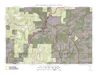
The day finally came for our departure. We had planned, mapped, purchased, and weighed our way to the start of great trip. Headed out of STL in driving rain, listening to what would be the Cardinals second to last game of their dismal post season showing, we settled in for the long drive to Trigg Tower. Members of this trip were Todd Whaley, Paul Caudell, David Tudor, Jeff Moore, Tim Dierking, Josh Heater, Al Evans.

We would meet our eighth member at Trigg Tower, John Voigts, author of the
River to River Trail Pocket Guide. Arriving in the parking lot of the tower, we spotted two tents that had been setup during a lull in the storm by John for us to use that first night. We already liked him as our first impression was that of generosity. Hand shakes all around and the cars sped off for the end of the trail. The remaining few set up a couple more

tents and built a fire. The fire began to pop and flames finally stretched above the highest perched logs when a neighbor from down the road spotted us and pulled in. He offered us shelter if things got bad later in the night…what did he know that we did not? As our conversation ended, the rain came on strong, taking our fire with it. We all jumped in our tents and went to sleep as the rain began to pound. We awoke the next morning to wet

gear, wet tents, and the rain continuing to make sure all became equally soaked. Gear packed and compasses pointed in the right direction, we set off for our first taste of the River to River Trail. The trail was soaked and we immediately came to terms with being wet. Most had taken precautions to keep our cores dry and since the temperature was quite decent there wasn’t too much concern for getting dangerously cold. Water crossings

became easier as most opted to simply motor through each one without any regard for even searching for a rock to jump on. After a few miles we came to a train crossing where we took a break from the rain. Our surroundings were slightly different from the Ozark Mountain region that we were used to, as the terrain seemed to be more open within the forest and the valleys were slightly broader, offering increased visibility. This

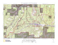
helped with the closed in feeling from all the rain and being stuffed inside our rain jackets. We continued on westward headed for the Lusk Creek Wilderness trailhead for night one in the backcountry. However, things didn’t go as planned. Once at the trailhead, and making 18 miles for the day, we knocked on the door of the
Circle B Ranch and asked the owners if they could put us up for the night. Once inside the tack shop, we got a fire

going in the stove and all our gear hung from every available hook in the place. Alcohol stoves roared as our water came to life for our freeze dried meals. A group of equestrians came in with a guitar and an impromptu jam session ensued that even featured one of our own, Paul. Connie, co-owner of the Circle B, offered to take all our clothes to the dryer in her house which resulted in us continuing the music session in our underwear. They were

trail angels in deed. The next morning, the rain had stopped, the sun was out, and we were dry for the first time in over 24 hours. We thanked our new friends and headed off into Lusk Creek Wilderness, stopping at features like “Saltpeter Cave” and “Secret Canyon”. These features were off of the River to River Trail and in order to get back on track we embarked on some off trail hiking that would get us to a connector

trail…however…not trusting some roads we ended up miles North of where we wanted to be. Consulting the map, we decided to perform an arduous road march that would get us to our next destination, the town of Herod. Upon entering Herod we took rest in the front yard of a house that had installed a hand pump to a natural spring. We filled up on the fresh water and continued on our way. A short distance later we entered Garden of the

Gods Wilderness Area. We had met some hikers on the south side of Herod who told us of a great camping spot high on a bluff a few miles into Garden of the Gods. Once we saw the site, we knew this was the spot they spoke of…and we dropped our packs having completed only about 13 miles that day. The view from our camp was long, and the smell of dinner lulled us into a lucid state. We started a fire and were able to find poor

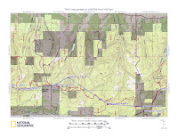
reception to listen to the final game of the Cardinals season; soon after we turned in for the night. We awoke the next morning to the bright sun, packed up, and headed out for the main attraction at Garden of the Gods. A few hours later we were climbing and jumping on the ancient sand beaches overlooking a sea of green deciduous. Lunch time came and went as the hordes of people peered fearlessly over the edges to experience the

scene for themselves. A Forest Service employee named Jim talked mountain lions with us for a while and then inquired about the trail conditions we experienced over the past 38 miles. Our cars were only 6 miles away, so we took one last look and plunged back into the forest, cruising past miles of sandstone walls. The closer we got to the end, the more apparent it was that this stretch was heavily used by horses. The trail had become

very muddy and rutted, with a criss-cross of paths that tried to avoid the deeper mud pits. We emerged from the forest and into a scene from the old west at High Knob campground. A combination RV and horse trailer vehicle dominated the field with tied up horses everywhere. We said hello as we passed while putting our trekking poles on pause. We made it to High Knob and took some final pictures of our packs before

heading home for dinner. Our experience on the River to River Trail had come and gone, but future trips are already in the works. Thanks to Todd and John for planning the trip and leading the group through these great places. jm


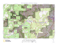
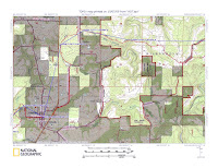
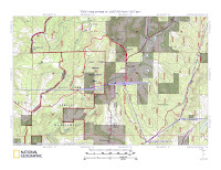
Topo Maps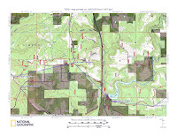
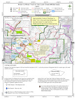
 As we neared Leasburg it started to drizzle; an aspect I didn't catch in the forecast as I prepared the trip. We donned our packs and hiked south into the Huzzah Conservation Area. The rain held steady, but light, so we left the shells in our packs. We made our way through the maze of logging and MDC utility roads and down into the Courtois Valley. It was still cold and rainy as we prepared to ford the Courtois Creek. As our naked feet
  slipped into the water, we realized just how cold the water really was. By the time we reached the other side the frigid water had caused searing pain. I knew then that tomorrow when I came across this again, I would be leaving my shoes in place. We continued up to The Narrows and began seeing eagles. We watched as they soared up and down the river, rested in the Sycamores that lined the banks, and then repeated the
  process. Wiggling along The Narrows we reached the other side and dropped down into the Huzzah Valley. We continued for a few more miles and found a nice campsite below the trail. As we prepared dinner and a fire the rain began to increase. We ate fast and turned in for the night...at 7:00. I slipped under my new MLD Grace Solo Siltarp and watched as the rain bounced off. The next morning the sun was out and David and I
  continued southbound to review some trail that Shawn Bradley, Neil Wiggins and I had worked on almost two years before. The trail looked great, especially near the tree that Shawn had to use excessive force. We got back to camp and woke Devin up, broke camp, ate breakfast, and began our trek back to the car. Not 10 minutes into our hike we were graced with a beautiful Barred Owl swooping down through the forest. Back through
  The Narrows and into the Courtois Valley we were faced with the cold crossing again. This time we left our shoes. We made our way up and out of the Courtois Valley and back to the car. From car to car, this trip lasted about 26 hours and contained some of the best trail yet. The total mileage out and back was about 16. jm


